Waning Gibbous Moon
The drive between Alturas and Susanville, CA on Hwy 395, as is typical of that highway, features rural grazing landscapes and grand, long-view stopping places. It's not as spectacular as the more famous Eastern Sierra extravaganza-land to the south, but it's also not as crowded with doofus hipsters and freeloading van life creatures. Haha, I sound like a 70 year old man, haha. Much of this land is federally managed, so there are places you can pull over and watch migrating birds and whatever else you are lucky enough to see.
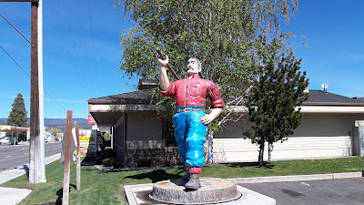
Before long, Susanville comes into view. I like this town a lot. At 4,186 feet, residents experience four distinct seasons. I am sure you can name them, but just in case, here is a helpful hint/acronym: WSSF. With a population of just under 18,000 humans, it is not too big, yet it offers services like Lassen Community College and Lassen Medical Center. The Susan River runs through town, there are snow skiing opportunities, and just about every outdoor pursuit imaginable is within easy reach. Now that I have told you it is a really cool place, please stay away - unless of course, you are passing through and want to drop some bucks at places like the Lumberjack Restaurant. I did, taking in a righteous breakfast-for-lunch experience and the chance to examine up close the silly thing pictured below. It is really hard to miss the Lumberjack Restaurant.
While I was chowing down, I thought about the last time I was in Susanville, two years ago on my convoluted bicycle ride down to Lake Tahoe from Klamath Falls. At that point, I was just beginning to do my research on the tribal bands along the Pacific Crest Trail in this area and I stopped into a small office near the Public Library with a sign on the door that read California Tribal TANF Partnership. TANF, I learned, stands for Temporary Assistance for Needy Families. This office helps to coordinate social programs for Maidu, Washoe, Paiute, and Pit River Indigenous people of the Susanville Rancheria. All of these tribal bands are descendants of natives who lived on land now crossed by the Pacific Crest Trail. Some of the living members still do.
The nice women who worked there two years ago were receptive to my book idea and they provided me with copies of a few maps they had on hand. Overall, they were very encouraging, something I greatly appreciated and have never forgotten. So this time, I walked back into their office with a copy of Walks Far Man in hand and delivered it to the nice lady at the front desk (she was not one of the ones I talked to two years ago, but just as friendly). I explained my story and asked her to read it and share it with her friends. I left feeling like something had come full circle. I really liked that feeling.
The next thing on the agenda was a quick walk on the Bizz Johnson National Recreation Trail. This is a Rails to Trails Hall of Fame Trail (converted railroad track) that runs from the old Susanville Railroad Depot near downtown about 25 miles through the Susan River Canyon to Mason Station (basically northwest toward Old Station, CA and Lassen Volcanic National Park).
My quick walk from the depot to Hobo Camp and back left me wanting more. I shall return, hopefully with a mountain bike and camping gear.
There was more to this day, but I will save that for the next installment. Susanville rocks!
Peace, Love, and Towns I Love,
Jim


No comments:
Post a Comment
Note: Only a member of this blog may post a comment.