Friday, January 28, 2022

Almaden Quicksilver Park Revisited

 Waning Crescent Moon

I went back to this park yesterday to hike the eastern half of the Bay Area Ridge Trail segment from Mockingbird Hill to English Camp. This piece began right at the edge of suburbia with groomed trail, lush green grass, and photogenic mammals. It quickly became quite steep with great views of sprawling, nearby San Jose. Although a little hazy, it was a good day for a healthy workout on the way back up to Mine Hill. 


Much of the upper portion was forested and shady. There were lots of interesting trees as well as outstanding outcrops of serpentinite and cinnabar. Once again, the bicyclists were courteous and there were only a few stray pieces of litter. It might sound funny to you that I even bother to remark about those things, but I'm giving credit where credit is due. Leave No Trace is more than a slogan. It's a lifestyle and a very positive one.


My favorite place on this hike was the San Cristobal Tunnel, which was my turn around spot. This (now closed) tunnel leads to the San Cristobal Mine on Mine Hill and it dates back to 1866. Old mines and tunnels are somewhat mysterious and 100% historically important, not to mention potentially dangerous. For fans of spooky superstitions, it might be fun for you to read a little about tommyknockers!). It's probably a good thing that these places are blocked off from the over-curious, careless, and clumsy among us, but it's also good that we get to peer inside in wonder. Just imagine the work that went into this tunnel's construction.


The hike back to Hondo featured lots of downhill grunting, but I was able to get on the road and beat most of the traffic to once again be safe at home. This month of increased activity away from my own backyard has been fun and rewarding. With only three days left to hike in January, I am on pace to reach my mileage goal for the year (157 miles so far), I have pieced together 60 of the 400 miles of the Bay Area Ridge Trail, and I have topped out on 13 of the Nifty Nineties. The BART and the Nifty Nineties will get tougher and tougher to complete because pretty soon I will have hiked all the stuff that is closest to me. Hello, Bay Area traffic jams.

My great friend and geoscience mentor Rob Negrini saw my previous post on the New Almaden area and messaged me about a Wallace Stegner book called Angle of Repose for which Stegner received a Pulitzer Prize in 1972. The book, divided into five parts, covers the history of four generations of an American family as told by a retired historian confined to a wheelchair. Part II is set in New Almaden and is centered around the experiences of a mining engineer named Oliver Ward. Stegner was a master novelist and Stanford professor, whose students included Ken Kesey, Larry McMurtry, and Edward Abbey. Angle of Repose is recommended reading for certain.


Peace, Love, and 2,022 in 2022,
Jim 

Tuesday, January 25, 2022

Castle Rock State Park - Goat Rock Loop

 Waning Crescent Moon

On another perfect, crisp, cloudless day for hiking, I drove up to Castle Rock State Park near Saratoga to hike the Saratoga Gap loop trail and visit Goat Rock, one of the Nifty Nineties. I was also hoping to see a good flow at Castle Rock Falls, which is on the way and part of the loop hike that skirts one of the many ridges in the Santa Cruz Mountains. This park and much of the surrounding area showcase the Oligocene Vaqueros sandstone formation and its signature tafoni. The ridges look like forested waves and the tafoni come in so many varieties of shapes and sizes that they defy the imagination. They can be fist-sized and shallow to cave-sized and deep enough to crawl into. For those folks who are unable to hike the trails here, Indian Rock is a beautiful outcrop right next to Skyline Boulevard. A parking area provides good access. 


Castle Rock Falls is a quick hike from the trailhead, following the loop trail in a clockwise direction. The spring-sourced falls drop dramatically about 80 feet almost straight down in a gorgeous, wooded setting. To prevent most of the daredevil selfie takers from plunging to certain death, the thoughtful park administrators have erected a viewing platform with sturdy metal rails. Judging from the well used trails that descend around the safety platform, lots of nimble shutterbugs risk their lives anyway. What can you do? On this particular day, the flow was just a thin, but steady ribbon of water that gave me a hint of what it might be like in a period of regular rainfall. It was still fun to be there and the sound was captivating. 


The trail along the ridge below Goat Rock is sunny and rocky, a little bit of a challenge for old knees, but not more than I could manage. There were several places where I scrambled in a crouch through tricky sandstone boulders. The rest of it was pretty normal up and down single track. It was good, sweaty fun as the day warmed up and the trail became more exposed. 


Eventually, the trail loops around past the Castle Rock Trail Camp and heads toward Goat Rock through old oak and madrone forest with occasional boulder scrambles and side trails to overlooks named after people whose names I did not recognize. This area is widely known and used by climbers. Perhaps the overlook people were involved in that sport or perhaps they helped acquire the land for the park or perhaps both? 


The trail approaching and leaving Goat Rock is steep and rocky, but fun to hike. I slowed way down for this part, receiving kind smiles and encouragement from youthful hikers carrying ropes and helmets. When asked, I replied, "I am in my 71st year, thank you very much." There were a couple of friendly young bucks sitting atop the rock itself. It looked like a doable hoist from the trail side. The other side was steep and would require skills and flexibility I do not possess. I was happy to be there and to inspect the various routes upwards. I had no problem deciding to move on after a snack and a swig of water. The steepest part of the trail turned into the easiest part due to a set of stairs provided by those busy park people. Thank you so much. 
"I'm learning to fly, but I ain't got wings, coming down is the hardest thing." - Tom Petty.


It was uphill and less rocky most of the way after that, with lots of beautiful trees and tafoni outcrops. One outcrop had smallish rounded boulders still embedded in the sandstone matrix, giving me a glimpse into how some of  the tafoni may have formed. Some day, slightly acidic rain water (pH ~ 5.5) may soak into the rock and dissolve enough of the calcareous (calcium carbonate) cement holding the sandstone together to allow the boulders to escape their prison, leaving behind a curious depression. That's my story and I'm sticking to it. At least until somebody who is more schooled in sedimentology tells me something different. I ain't proud. 


Overall, this is a great trail to exercise your gluteus maximus, work up a sweat, and ponder the mysteries of Oligocene deposition, compaction, and cementation, plus subsequent tectonic movement along the San Andreas, not to mention the acrobatic hijinks of rubber-jointed, agile rock climbers. What a great way to get to know a little piece of California.


Peace, Love, and Tafoni,

Jim

Friday, January 21, 2022

Almaden Quicksilver Park, Santa Clara County, California

 Waning Gibbous Moon

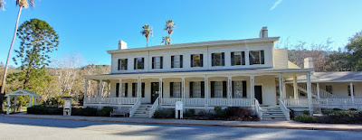
Almaden Quicksilver Park, near the small community of New Almaden in Santa Clara County, on Mutsun Ohlone ancestral lands south of today's San Jose, was once a booming center of mining for cinnabar, the red ore of mercury (aka quicksilver). The study of Earth Science tells us that through the slow grinding of tectonic plates and interaction with hot water beneath Earth's surface (hydrothermal alteration) serpentinite can gradually metamorphose into cinnabar. That's what happened here. After millions of years, this location contained one of the most productive (mineable) cinnabar sites in the world. Today, the New Almaden Quicksilver Mining Museum is a terrific resource for both the history and geology of the region.

Casa Grande houses the New Almaden Quicksilver Mining Museum

Mining of the ore was a vital industry from 1847 to about 1870 as the California Gold Rush boomed and mercury was used to extract gold from the ore mined in the Sierra Nevada. Major mining operations ceased in 1912, ending completely in 1976 as the toxic environmental consequences of mercury contamination became better understood. The fish in Guadalupe and Almaden Reservoirs to this day contain harmful amounts of methyl mercury. Catch and release only! 

In the county park, you can still see lots of evidence of excavation and equipment and former settlements, but access to mine entrances and tunnels is blocked for obvious reasons. There are 38 miles of hiking trails, including a stretch of the Bay Area Ridge Trail. Yesterday, I hiked six of those miles and added Mine Hill (1,728 feet) and Church Hill (1,450 feet) to my Nifty Ninety scorecard. Horses and mountain bikes are also allowed on the park trails. I found the few bicyclists that I encountered to be courteous and safe, which I greatly appreciate. I saw absolutely zero litter or graffiti on this hike. Bravo!

A lot of the trails are exposed to the direct Sun, but there are occasional tree-lined segments.

A considerable effort has been made to educate and inform users of the park about the land's history and cultural importance. I found the rocks and the old, rusty remains of the furnaces and settlements most interesting. 


The best long view I found was from Church Hill, an easy walk up from the rest stop at English Camp.


The damage that the era of mining and development has done (and continues to do) to plants, animals, soil, and water at New Almaden is irrefutable. The effects on humans are probably greater than we let on. But the efforts at education and the creation and use of this park are positive outcomes. Maybe, just maybe, we are getting smarter and things are getting better.

Peace, Love, and Learning,
Jim

Tuesday, January 18, 2022

Sierra Azul Open Space Preserve - Bald Mountain

 Full Moon

 A few years ago, I hiked from the Bald Mountain parking area in the Sierra Azul Open Space Preserve near New Almaden, CA up to Mt. Umunhum and back. At the time, I didn't know much about the Bay Area Ridge Trail (BART) or the Nifty Ninety, but I knew I wanted to return to the area and hike some more trails. Yesterday I did just that.

Bald Mountain (2,387 feet) is an easy walk-up from the parking lot. It only takes about 20 minutes to get to the top, including time to gawk at the manzanitas and take pictures of the mountains. You might wonder why this peak was selected as one of the Nifty Ninety until you get up there and realize that hey, this place is really nifty. The views, even on a hazy, overcast day, are sweet in every direction and you didn't even get out of breath to see them. Great spot to take little kids, even big little kids.


Returning to the parking lot, I crossed the road to the trailhead for the Umunhum Trail that Captain Chem and I hiked in 2018. After a few tenths of a mile, the trail splits, with one going up to the mountain and the other, Barlow Road, taking off toward the Woods Trail on the other side of the Guadalupe Creek drainage. This was my hiking goal for the day - a bunch of ups and downs to Woods Trail and back, so I would have this little corner of the BART completed. I'm not 100% certain I want to finish the entire 400 miles of the BART, but I am chipping away at it. I really don't care how long it takes or if I do the whole thing. I just like to hike.


I didn't see one animal on or near the trails, not even a bird. Yesterday was a holiday for a lot of people and a big chunk of them were outside messing around like me. The parking lots were full, but the hikers were pretty spread out. I was impressed by how clean the trails were here and everybody I encountered had masks (most worn around their necks at the ready if they needed them - me, too) and were quietly friendly. Even the mountain bikers were courteous. I like that. 

Visually, the Barlow Road hike wasn't super-wonderful, but it was a good out and back workout. I am starting to get my legs back after last year's relatively slothful, mostly flat, road-walking, beach-walking miles (just over 1,800 or 4.9/day). Climbing hills is so much better for your conditioning. On to the next one. Back to Henry Coe?

Peace, Love, and MLK,

Jim

Saturday, January 15, 2022

Chitactac Adams County Park - Santa Clara County, California

 Waxing Gibbous Moon

In keeping with my 2,022 in 2022 program, I am reaching out to visit as many parks as I can to satisfy two intentions: a) to learn something new and b) to get some more miles in. On my way home from Uvas Canyon the other day, I saw the sign for Chitactac Adams County Park. I had heard of it before, but never had I purposefully looked for it. The park sort of popped up in front of me, so I had to stop. It was my time to see it.


This park is part of an old Amah Mutsun village called Chitactac situated on Uvas Creek upstream of the Pajaro River on Watsonville Road northwest of Gilroy. There is a small visitor center styled very loosely after a roundhouse with a set of displays explaining the ancient and recent history of the land. The "Adams" part refers to a 19th century "landowner" who donated the property to the local school district.


Chitactac was populated for about 3,000 years pre-colonial times. Evidence of some of their activities is still present in the form of pictographs and grinding holes on sandstone outcrops next to the creek. The "nature trail" loops around the site with barriers to protect the pictographs. The outcrops are very mossy right now, so the pictographs are difficult-to-impossible to see. If you go, please respect the need to preserve them and do not climb over the barriers. 

This pictograph has been removed from its original location.
It is currently on display in the visitors center. 

The grinding holes are many and they are easy to see and enjoy.


It is also easy to imagine a busy village at this location with salmon swimming upstream to spawn and lots of game nearby. The eroded sandstone outcrops are beautiful and provide interesting cubby holes to explore. 


A ramada near the visitor center is a nice place for a picnic. It is also loosely styled after a native shelter. 


Several large boulders in the park have been defaced by vandals in recent times. I'm not sure the damage can be erased, but it would be a worthy project for a youth group. Today's anthropologists and others who study pictographs are not certain how to interpret their precise meanings. It is safe to say, however, that they are not pledges of puppy love or gang affiliation, like the crude letters and numbers carved into rocks by modern children. Leave no trace, people. We have  done enough harm.

Peace, Love, and Let It Be,
Jim