Friday, January 21, 2022

Almaden Quicksilver Park, Santa Clara County, California

 Waning Gibbous Moon

Almaden Quicksilver Park, near the small community of New Almaden in Santa Clara County, on Mutsun Ohlone ancestral lands south of today's San Jose, was once a booming center of mining for cinnabar, the red ore of mercury (aka quicksilver). The study of Earth Science tells us that through the slow grinding of tectonic plates and interaction with hot water beneath Earth's surface (hydrothermal alteration) serpentinite can gradually metamorphose into cinnabar. That's what happened here. After millions of years, this location contained one of the most productive (mineable) cinnabar sites in the world. Today, the New Almaden Quicksilver Mining Museum is a terrific resource for both the history and geology of the region.
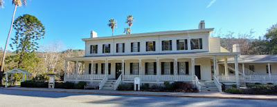
Casa Grande houses the New Almaden Quicksilver Mining Museum

Mining of the ore was a vital industry from 1847 to about 1870 as the California Gold Rush boomed and mercury was used to extract gold from the ore mined in the Sierra Nevada. Major mining operations ceased in 1912, ending completely in 1976 as the toxic environmental consequences of mercury contamination became better understood. The fish in Guadalupe and Almaden Reservoirs to this day contain harmful amounts of methyl mercury. Catch and release only! 

In the county park, you can still see lots of evidence of excavation and equipment and former settlements, but access to mine entrances and tunnels is blocked for obvious reasons. There are 38 miles of hiking trails, including a stretch of the Bay Area Ridge Trail. Yesterday, I hiked six of those miles and added Mine Hill (1,728 feet) and Church Hill (1,450 feet) to my Nifty Ninety scorecard. Horses and mountain bikes are also allowed on the park trails. I found the few bicyclists that I encountered to be courteous and safe, which I greatly appreciate. I saw absolutely zero litter or graffiti on this hike. Bravo!

A lot of the trails are exposed to the direct Sun, but there are occasional tree-lined segments.

A considerable effort has been made to educate and inform users of the park about the land's history and cultural importance. I found the rocks and the old, rusty remains of the furnaces and settlements most interesting. 


The best long view I found was from Church Hill, an easy walk up from the rest stop at English Camp.


The damage that the era of mining and development has done (and continues to do) to plants, animals, soil, and water at New Almaden is irrefutable. The effects on humans are probably greater than we let on. But the efforts at education and the creation and use of this park are positive outcomes. Maybe, just maybe, we are getting smarter and things are getting better.

Peace, Love, and Learning,
Jim

Tuesday, January 18, 2022

Sierra Azul Open Space Preserve - Bald Mountain

 Full Moon

 A few years ago, I hiked from the Bald Mountain parking area in the Sierra Azul Open Space Preserve near New Almaden, CA up to Mt. Umunhum and back. At the time, I didn't know much about the Bay Area Ridge Trail (BART) or the Nifty Ninety, but I knew I wanted to return to the area and hike some more trails. Yesterday I did just that.

Bald Mountain (2,387 feet) is an easy walk-up from the parking lot. It only takes about 20 minutes to get to the top, including time to gawk at the manzanitas and take pictures of the mountains. You might wonder why this peak was selected as one of the Nifty Ninety until you get up there and realize that hey, this place is really nifty. The views, even on a hazy, overcast day, are sweet in every direction and you didn't even get out of breath to see them. Great spot to take little kids, even big little kids.


Returning to the parking lot, I crossed the road to the trailhead for the Umunhum Trail that Captain Chem and I hiked in 2018. After a few tenths of a mile, the trail splits, with one going up to the mountain and the other, Barlow Road, taking off toward the Woods Trail on the other side of the Guadalupe Creek drainage. This was my hiking goal for the day - a bunch of ups and downs to Woods Trail and back, so I would have this little corner of the BART completed. I'm not 100% certain I want to finish the entire 400 miles of the BART, but I am chipping away at it. I really don't care how long it takes or if I do the whole thing. I just like to hike.


I didn't see one animal on or near the trails, not even a bird. Yesterday was a holiday for a lot of people and a big chunk of them were outside messing around like me. The parking lots were full, but the hikers were pretty spread out. I was impressed by how clean the trails were here and everybody I encountered had masks (most worn around their necks at the ready if they needed them - me, too) and were quietly friendly. Even the mountain bikers were courteous. I like that. 

Visually, the Barlow Road hike wasn't super-wonderful, but it was a good out and back workout. I am starting to get my legs back after last year's relatively slothful, mostly flat, road-walking, beach-walking miles (just over 1,800 or 4.9/day). Climbing hills is so much better for your conditioning. On to the next one. Back to Henry Coe?

Peace, Love, and MLK,

Jim

Saturday, January 15, 2022

Chitactac Adams County Park - Santa Clara County, California

 Waxing Gibbous Moon

In keeping with my 2,022 in 2022 program, I am reaching out to visit as many parks as I can to satisfy two intentions: a) to learn something new and b) to get some more miles in. On my way home from Uvas Canyon the other day, I saw the sign for Chitactac Adams County Park. I had heard of it before, but never had I purposefully looked for it. The park sort of popped up in front of me, so I had to stop. It was my time to see it.


This park is part of an old Amah Mutsun village called Chitactac situated on Uvas Creek upstream of the Pajaro River on Watsonville Road northwest of Gilroy. There is a small visitor center styled very loosely after a roundhouse with a set of displays explaining the ancient and recent history of the land. The "Adams" part refers to a 19th century "landowner" who donated the property to the local school district.


Chitactac was populated for about 3,000 years pre-colonial times. Evidence of some of their activities is still present in the form of pictographs and grinding holes on sandstone outcrops next to the creek. The "nature trail" loops around the site with barriers to protect the pictographs. The outcrops are very mossy right now, so the pictographs are difficult-to-impossible to see. If you go, please respect the need to preserve them and do not climb over the barriers. 

This pictograph has been removed from its original location.
It is currently on display in the visitors center. 

The grinding holes are many and they are easy to see and enjoy.


It is also easy to imagine a busy village at this location with salmon swimming upstream to spawn and lots of game nearby. The eroded sandstone outcrops are beautiful and provide interesting cubby holes to explore. 


A ramada near the visitor center is a nice place for a picnic. It is also loosely styled after a native shelter. 


Several large boulders in the park have been defaced by vandals in recent times. I'm not sure the damage can be erased, but it would be a worthy project for a youth group. Today's anthropologists and others who study pictographs are not certain how to interpret their precise meanings. It is safe to say, however, that they are not pledges of puppy love or gang affiliation, like the crude letters and numbers carved into rocks by modern children. Leave no trace, people. We have  done enough harm.

Peace, Love, and Let It Be,
Jim

Friday, January 14, 2022

Uvas Canyon County Park - Waterfall Loop

 Waxing Gibbous Moon

Yesterday I returned to Uvas Canyon Park to hike the Waterfall Loop, plus the Contour Trail and the Alec Canyon Trail. It was a most pleasant way to spend a few relaxed hours on a partly cloudy, mildly cool day. These trails are not as strenuous as the Knibbs Knob Trail, so I didn't get as gassed as I did on Monday. There were many things to see and admire, but little wildlife. The presence of a half dozen small groups of hikers and their chatter saw to that. I'm sure they didn't mean to be loud and obnoxious and scare away the deer, they just weren't very aware of their surroundings. City folk. Different stroke.

The waterfalls were small but fun - nothing like the Sierra Nevada and Cascade Range waterfalls I am used to - but hey, what can you expect. I enjoyed walking along the creeks and seeing/hearing them, realizing how special this place is so close to large population centers. 


I especially like the way the flowing water sculpts and colors the rocks and the contrasting colors of the trees and moss. This park is really pretty and the trails are in tiptop shape. The Contour Trail provided some fun ups and downs and a few long views, reminding me of the views from Knibbs Knob. Along the way were some interesting mushrooms and tree shapes.


The Alec Trail led me to Triple Falls and the site of an old logging camp. The quality of my pictures doesn't do justice to the beauty of Alec Canyon's trees. This stretch is really special.


My 2,022 in 2022 goal is progressing without a hitch and it has pushed me to explore new (for me) places in the nearby woods. I  think next week I will try to climb Bald Mountain and maybe one or two others. I will definitely be hiking some more trails in the area south of San Jose. Fun!

Peace, Love, and Footsteps,
Jim

Tuesday, January 11, 2022

Uvas Canyon County Park - Knibb's Knob

Waxing Gibbous Moon

The word knob is derived from the Scandinavian word knobe, in case you were wondering, and in this usage, according to my Smartyphone, it means a round, prominent hill. Henry Knibb was a pioneer who homesteaded some land in the area in 1891. Knibb's Knob (2,694 feet) is a peak in today's Uvas Canyon County Park in the Coast Range west of Morgan Hill, CA. 

Before Henry and others moved in and, as was fashionable in those days, declared ownership of the land out of the clear blue sky, Knibb's Knob and everything else as far as the eye can see was Amah Mutsun territory and had been for thousands of years. Henry et alia commenced to cutting down trees and selling them to support the nearby New Almaden Quicksilver Mine, California's oldest (1845) mining operation. Quicksilver (mercury) was used as a reduction agent in gold production and the rest, including today's Silicon Valley, is manifest destiny. 

There is some goodness left in the world and thank goodness for things like county parks that preserve it. The Amah Mutsun have made an agreement with the county to limit daily human traffic to the area by use of a reservation system. Yesterday, with permit in hand, I ventured into Uvas Canyon to walk the Knibb's Knob Trail up to the peak (aka a prominent hill in the park). I wondered upon arrival what the Amah Mutsun call it (probably not Knibb's Knob, duh). Uvas Creek is flowing strong right now, so the little waterfalls that dot the park are in fine form. I didn't visit any of them on this trip. I will return soon to hike the Waterfalls Trail and enjoy them, too. 

The top of the wooded hill is only a little over two miles from the parking lot, but boy howdy, it's a steep two miles. I am loving my 71st year on this blessed planet immensely. However, my enjoyment yesterday was punctuated by regular grunting and the occasional wheeze. The 1.8 miles from the trailhead to the peak took me a little over an hour and a half, which is kind of ridiculous. I am officially and demonstrably old, but I managed to get over the hill without croaking. The trail is a wide, switch-backing fire road that snakes its way on a steady grade toward the summit. The views are great and the cool temperatures in the shade make the climb more bearable. 


The "peak" (rounded hill) is heavily wooded with a picnic table on top, where I feasted on my peanut butter and banana sammie and poked around a little to see what I could see. Despite taking so long to get there, I felt strong and happy to have made the trip. It's a special place to be sure. I am lucky to have seen it on such a beautiful day.


What goes up must come down, which is where hiking poles come in handy for the septuagenarian recreationist. I got back to Hondo in a gravity-aided hour, pleased with my Monday adventure and ready to come back to Uvas Canyon for more.

Peace, Love, and Stoked for Some Waterfalls,
Jim