Waxing Gibbous Moon
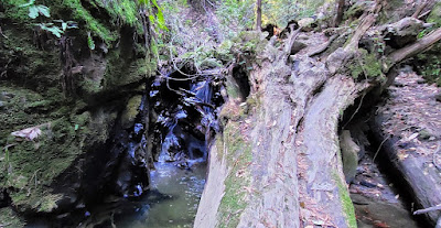
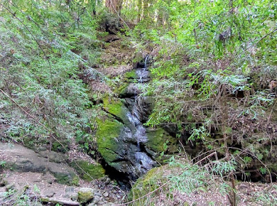
With a little stubborn effort and a lot of sweat, I managed to turn an 8-mile hike into a 10-mile hike yesterday. There was no magic wand involved, just a dumb jog to the right when I should have adroitly switchbacked to the left. This error led me to a steep mountain bike trail straight up to a ridge where I realized, un-adroitly, that Bridge Creek would not be flowing on top of a ridge and, duh, I was no longer on the Bridge Creek Trail. That realization was important because the Bridge Creek Trail was the way to Maple Falls, which was my semi-planned turnaround spot for the day. I didn't know if there would be any water in the falls this time of year, but finding out was a point of interest. My hike now had two turnaround spots and two extra miles. In the grand scheme of things, this was not a big deal, but still...
The weather was perfect and the redwoods and tan oaks were beautiful and there were hikers and joggers and mountain bikers aplenty when I left on foot from George's Picnic Area on Aptos Creek Road. That led me to Loma Prieta Grade Trail (a mile or so from the 1989 Loma Prieta earthquake epicenter) and eventually to the Bridge Creek Trail toward Maple Falls. My first choice had been Five Fingers Falls, but I learned that the trail to that one was closed. The Ranger at the park entrance said there were no plans to re-open it any time soon. I didn't mention to him that there are a dozen or more accounts of people hiking that closed trail available for downloading right that second on the internet. I didn't want to interfere with his illusion that the park was not full of happy-go-lucky people who didn't give a rodent's bee-hind about his closure info.
But, ever the copasetic rule follower, I went with Plan B to Maple Falls. And the road to the trails was great.


I even got to see a couple of banana slugs, always a fun experience at Nisene Marks.

After the aforementioned detour, the trail followed the creek into a steepening canyon. The trail crossed back and forth across Bridge Creek on two, you guessed it, bridges. I passed the Bridge Creek Historical Area, which was mostly a jumble of king-sized Lincoln logs.


No comments:
Post a Comment
Note: Only a member of this blog may post a comment.