Wednesday, April 27, 2022

Debell Uvas Creek Park Preserve, Gilroy, California

 Waning Crescent Moon.

I really like municipal bike paths that wind along local rivers and creeks. I have visited hundreds of them all over the United States and without fail, they provide positive, natural opportunities for all kinds of citizens to recreate in safe, healthy environments. Yesterday I had a checkup with an ophthalmologist in Gilroy, about 15 miles from my camp. When it was over, I changed clothes and parked at the Gilroy Sports Park, which marks the southern end of the town's bike path that parallels Uvas Creek. Little League baseball is a very big deal here. The fields (three or four, I think) are immaculate, with great big scoreboards and grandstands. Very impressive.


The wide asphalt trail is paved with mile/km markers painted every quarter mile/km. There seemed to be an equal number of bicyclists and walkers on the trail during the two hours I was there. I walked to the three mile marker and turned around for a pleasant, six-mile stroll. It was breezy shorts-and-tee-shirt weather, an absolutely perfect day to be outside. After passing by the backside of Gilroy High School and some more sports parks, the trail enters the boundary of the Debell Uvas Creek Park Preserve, which appears to be a relatively new segment associated with the sprawling subdivisions along Santa Theresa Boulevard. There is still plenty of creek bed and floodplain area to offset the imposing houses and the coastal mountains in the background also provide welcome relief. The closer I got to the houses, the more developed the trail was, with playgrounds and informative posters and water fountains. I am sure the developers paid the city fees to cover at least part of these amenities. That is standard procedure in most places from what I understand. That practice allows residents from the whole town to benefit from growth. 


My favorite parts of the trail were the murals painted on underpasses that protect trail users from the busier streets. The best of these murals, in my opinion, is the one (painted by artist Sheryl Cather) that features animals and scenery that are reminiscent of the time before the modern settlements began. It may portray a romanticized paradise that is not entirely accurate, but it IS beautiful and it calls us to strive for responsible stewardship of the place we call home. Way to go, Sheryl Cather.


I really enjoyed my visit to this linear park along Uvas Creek and I could tell by the expressions on the faces of the people I met along the way that they did, too. Well done, Gilroy!

Peace, Love, and Universal Bike Paths,
Jim

#2,022 in 2022

Thursday, April 21, 2022

Royal Oaks County Park, Monterey County, California

 Waning Gibbous Moon

It's raining this morning, a rare blessing this year, and it's a good time to sing a pre-Earth Day song in praise of water and life on our little blue planet. One of my favorites is Nature's Way by Spirit, which reminds us that we are not in charge of the big picture, but how we behave does make a difference over time. Spirit, by the way, was one of the best live bands I have ever seen and Randy California was a fantastic guitarist. This brief video only begins to showcase the band's talents. I'll leave it up to you to investigate further if that is something new to you.

Yesterday was sunny and pleasant, so I decided to visit Royal Oaks County Park in Monterey County about 25 minutes away toward the coast. On a Wednesday at mid-day, it was all but deserted, so I had free rein to explore most of the little trails that intersect with each other in a looping network around the park. I had no map, so I just winged it. All the trails I found were in really good condition, some of them appeared to be recently cleared, and there was nearly no trash that I could see. Like most areas around here, there is a good bit of poison oak, so beware of that if you go. 

This park is designed for public group activities. I imagine that sunny weekends draw lots of family events and kid stuff. There are tennis courts and a basketball court, plus playgrounds and horseshoe pits and huge picnic areas. It has a fun, active feel and I was glad to find good walking to boot. I started out at the first trailhead I found, the Coffeeberry Trail, which is close to the horseshoe pits on the edge of the woods. It is not very long, but it has some good up and down to it, so I hiked it twice to get my blood going. 


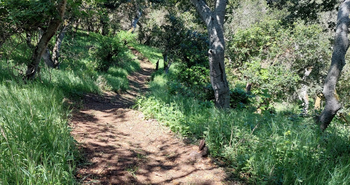
The Coffeeberry Trail lead me up to the Woodlands Loop to the Oak Ridge Trail. It's a fun hike with very soft tread and not a lot of footprints. If I was still able to run, all these trails would be great fun to motor through the shady woods. On the other hand, walking at old man speed lets me spy some of the little things.


Up on the ridge, the trail opens up to a wider, harder surface that allows service vehicles access in case of an emergency. I saw a few different benches up there which would be great spots for eating lunch or reading for a while or just sitting there to breathe and listen. 


I think a healthy, able person could probably hike all of the trails in Royal Oak Park in two hours or less. That is not to diminish the value of the experience in any way. If you wanted a more rigorous workout, you could do the circuit more than once or run it instead of walking. And aside from the trails there are plenty of open spaces and meadows to explore, too. Next time I go, I'm bringing my basketball to work on my jumper. Well, okay, there probably won't be a lot of jumping going on, but it will be fun nonetheless. A swish is a swish! What do people call it when they toss a perfect horseshoe toss? A ringer? A clang? A thunk?


Peace, Love, and Go Outside,
Jim

#2,022 in 2022

Friday, April 15, 2022

Fremont Peak State Park, California

 Waxing Gibbous Moon

In a continuing effort to conserve gasoline, yesterday I curbed my yearning for more new Bay Area Ridge hikes and motored 11 miles up San Juan Canyon Road to Fremont Peak State Park. I am very familiar with the trails there, but the overcast skies and cold wind provided a somewhat different feel to the park. I opted for a very enjoyable counterclockwise loop starting from and returning to the upper parking lot via the Fremont Peak Trail, Carmen's Trail, Tony's Trail, the Cold Springs Trail, and the Valley View Trail.

 I like to park next to these big oak trees by the caretaker's house.

The views were somewhat obscured by the cloud cover, but the walk around the peak was still engaging.

The Fremont Peak Trail sign has been vandalized since the last time I visited.


The end of that segment spit me out at the beginning of Carmen's Trail. About halfway down the gentle switchbacks, I was lucky enough to see a deer resting in the grass plus a variety of wildflowers. 


Carmen's Trail winds down into a drainage and contours up to a road near the Fremont Peak Observatory. Tony's Trail takes off from there. On Tony's Trail I saw a few wily turkeys who defied my attempts at a photograph. If you optimize one of these pictures and squint real hard, you might see a big Tom fanning his tail feathers for you.


The Cold Springs Trail is my personal favorite walk in this park. It twists in and out of oak and madrone forests before connecting to the Valley View Trail that leads back to the parking lot. By the time I was halfway through this homestretch, the wind had picked up and a light sprinkle had begun to blow.  I was starting to get chilled so I didn't lollygag much in these sections. 


I met a smart, friendly Bay Area couple camped where the Valley View Trail passes by the west end of the Oak Flat Campground. They had a snazzy, remodeled 1980's VW Westphalia pop-up camper and a very positive attitude about the funky and getting funkier weather. After an interesting, wide-ranging conversation in between shakes and shivers, we said adios and I sped away along the last segment of the trail, eager to hop into Hondo and head for home.

Peace, Love, and Brrrring Back the Sunshine,

Jim

#2,022 in 2022

Wednesday, April 13, 2022

Moss Landing State Beach, California

 Waxing Gibbous Moon


What do I like about Moss Landing State Beach? 1) It's close to home (25 minutes), 2) it's free, 3) the dunes are protected, 4) there are lots of animals, 4) it's mostly clean, and 5) you can walk in the sand for a few miles from the jetty to the mouth of the Pajaro River and turn around to do it again for another few miles. The weather here is usually good, but even if it isn't, the beach is still great. Also, the tiny town of Moss Landing has more than a few good places to eat, so if you get hungry, they gotcha covered. All that said, I'd prefer that you only visit once a year and leave the place to the locals the rest of the time!


Yesterday was windy and cold, but that's what layers are for. I suited up and walked my walk as the tide receded, leaving all kinds of cool stuff behind. I saw several places where curlews had been hunting for sand crabs, poking their long, curved beaks into the wet sand and hopping around the hole in a hurry to snag their prey before the waves might come in to interrupt the hunt. Their footprints and the hole told the story. I think this one must have been a success because it had not been washed away yet. 


About halfway toward the Pajaro River I passed a group of folks with their kids and dogs having fun in the surf. I asked what appeared to be grandparents standing back in the dry sand watching the scene if it was okay to take the kids' picture and they said okay. This is pure California. It makes me happy to see it. I can imagine this scene happening a thousand years ago - with different kids and different grownups and different dogs and different clothes, but with the same grins and giggles.


I didn't see many pelicans, gulls, vultures, or sea mammals, which was unusual, but I did see a lot of curlews, snowy plovers, intact shells, and sand dollars plus a ton of polished pebbles. I had a small towel in my daypack so just for fun I made a little display of some of the jewels I found. I appreciate the work that many artists and craftspeople put into their creations, but what I really like is straight-up Mother Nature. Each one of these things represent changes over time - cycles and and processes that never end - impermanent beauty frozen in this moment - destined to morph into something else. I love it.


Peace and Love from the Beach,
Jim

#2,022 in 2022 *

* My friend Jessica (Happy Birthday, Jessica!) made me think about this 2,022 hiking goal of mine. To clarify, the miles I am recording are only miles I walk toward this specific goal of hiking 2,022 miles this calendar year. I don't keep track of my total daily steps, but Jessica started doing that and she discovered that she was walking about three times as many miles every day as her normal daily 3-mile fast morning walk. So that 10,000-step thing that many people subscribe to really adds up and that  has to be great for your health. However you choose to do it, I hope you walk or hike or bike or run, etc. for your mental and physical health every day. You don't have to keep a running total if you don't want to, but it can add to the fun and keep you committed to daily exercise and the act of paying attention, which for me is the whole point.